DISCOVER DERBYSHIRE
AND THE
PEAK DISTRICT
|
DISCOVER DERBYSHIRE AND THE PEAK DISTRICT |
|
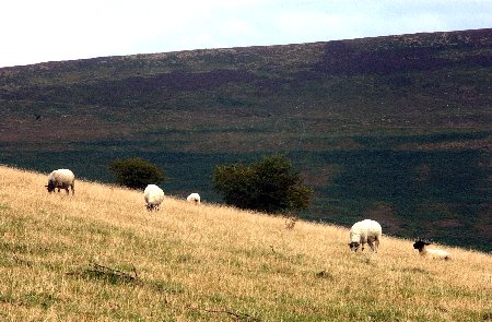
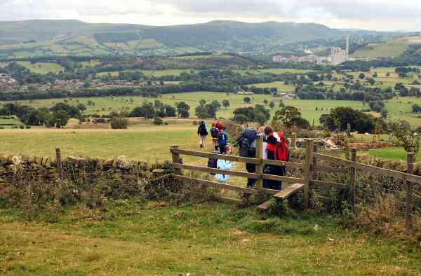
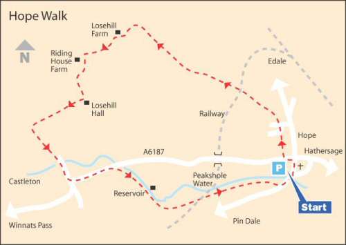
HOPE WALK THE WALK Apart from a steady climb up to Losehill Farm, this walk is relatively easy and manages to pack in plenty of variety as well as magnificent scenery. The path descends gently from Losehill Farm with glorious views over the Hope Valley to Losehill Hall, the training centre for the Peak District National Park. Set in 27 acres of parkland, gardens and woodland the Victorian Hall is of considerable architectural interest. Continue through a series of fields before following a farm track, passing an outdoor activity centre on the way, to join Hollowford Road that leads to Castleton. Apart from the magnificent scenery, Castleton is famous for its four show caverns of which only Peak Cavern is a true cave. Castleton is soon left behind and Peakshole Water, named after its source at Peak Cavern, is followed for a short distance. After crossing a railway line used by the Cement Works, it is not long before Pindale Road is reached. Look out for the well-preserved Pinfold by the bridge over Peakshole Water as you return to Hope.
WALK DETAILS Length: 6 miles. Start/finish: Hope Car Park on the left, just after the village centre, on the route to Castleton. Location: On A6187 between Castleton and Hathersage. Terrain: Long, steady climb up to Losehill Farm, but mainly flat, easy walking.
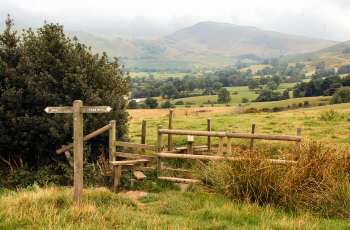
THE ROUTE 1. Turn right out of the car park and immediately after passing Woodbine Café and the Blacksmith’s Cottage, go to the left through a narrow opening and in 25 yards ascend a short flight of steps by a footpath sign ‘Lose Hill – Mam Tor’. 2. Cross a short field through two kissing gates and continue straight on up an estate road, crossing the road at a ‘T’ junction to a stile on the opposite side. 3. Continue straight ahead along the right edge of the field, before walking on the opposite side of the field boundary for a short distance but without changing direction. 4. The route is easy to follow and leads to a bridge over a railway line. 5. On the other side, the path goes over a short field to cross a stile and continue to the right of a house up a driveway by outbuildings and over another stile. 6. You now walk along a fenced path, before crossing a cart track and continuing with the hedge on your left. 7. Continue climbing without deviating in direction heading towards Losehill Farm, crossing an open field, passing close to a barn on the right, over a stile and up another field to join a wall on the left. 8. On reaching the farm take the ‘Castleton’ sign to the left and then in a few yards go left again, where the path guides you in front of the house onto the driveway. 9. By the drive gateway take the stile on the right and walk straight across two fields to join a cart track. Where the track turns to the left, carry straight on and walk along the top side of a field to a stile in the corner. 10. Turn left and just before reaching Riding House Farm, turn left again and head to the bottom right corner of the field. Go down a flight of steps and over a stream and up the other side into another field. 11. Immediately turn left and walk down a clear path to reach the road at the back of Losehill Hall. 12. Turn right and where the road bends to the left, walk straight on across a field going over a stream in the corner, before angling slightly to the left across the next field to reach a farm driveway. 13. Go through the double gates at the end of the drive and continue along the road, which soon swings to the left, before reaching Castleton. 14. From Castleton, turn left along the A625 and walk to the outskirts of the village. 15. After passing a small field, turn right at the footpath sign for ‘Hope’ and walk up a walled lane that leads to a rough track. 16. On leaving the track a fence is followed first on the left and then on the right, before crossing several fields along a distinct path. 17. Soon a railway line is crossed and after that you just follow the gravelled path to Pindale Road. 18. Turn left down the road and then left again at the main road back to the start of the walk.
Return to the Home Page Back to the top of the Page Return to the Contents Page www.derbyshire-peakdistrict.co.uk is an independent, not for profit website. No recommendation of any establishment is implied by inclusion on this website.
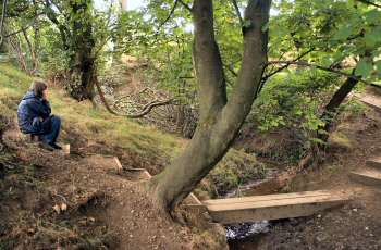
|
PLACES OF SPECIAL INTEREST IN THE AREA Ladybower and the Derwent Valley is a very popular area for visitors. The dams in the valley were used by Dr Barnes Wallis and his team to test his bouncing bombs, and the film ‘The Dambusters’ was partly shot here.
Castleton Caverns without doubt the most spectacular collection of caverns in the country. Speedwell (tel 01433 620512), Blue John (tel 01433 620638), Treak (tel 01433 620571) and Peak (tel 01433 620285).
Edale where the Nag’s Head Inn is the traditional starting point of the 270 mile Pennine Way Trail, as it winds its way north to the Scottish border at Kirk Yetholm.
The Peak District National Park’s Field Head Visitor Centre is also here.
REFRESHMENTS Woodroffe Arms Hotel (Tel 01433 620351) named after an influential local family, this ancient pub provides a wide range of traditional food served at lunchtimes and in the evenings throughout the year. Some outside seating and a play area for children. Accommodation available. Woodbine Café (Tel 01433 621407) this delightful little café was once a pub named the Blacksmiths Arms and the building dates back to the 17th century. Hot and cold food mostly cooked on the premises is served. Open daily.
THE DISCOVER DERBYSHIRE AND THE PEAK DISTRICT GUIDE
Provides a wide range of features with heritage trails and detailed countryside walks, through some of the most scenically attractive countryside in the UK.
1. To return to the main site click the link below. 2. To return to the contents page of the main website click the link below.
DISCOVER DERBY A special new sub-section has been added to this website, based on the Discover Derby Supplement, published by the Derby Evening Telegraph during March 2005. The most recent additions are: Click below for details.
ON THIS SITE Every month an illustrated Newsletter is published giving details of: What's New, What's Coming and What's On.
HOPE FEATURE A village of great antiquity at the confluence of Peakshole Water and the River Noe in the Hope Valley, it was a centre of pre-historic trackways and later Roman Roads. The Romans most important fort in the Peak District was established at Navio, only one mile away from Hope. In 1086, at the time of the Domesday Survey, Hope covered two thirds of the Royal Forest of the High Peak and was one of the largest parishes in the country. Hope was one of the earliest centres of Christianity in the area and the church was the only one mentioned in North Derbyshire in the survey. People from a wide area around the village came to be married at the church for many years after the Norman Conquest.
All details on this page were correct at the time of publication, but changes may be made without notification. |