DISCOVER DERBYSHIRE
AND THE
PEAK DISTRICT
|
DISCOVER DERBYSHIRE AND THE PEAK DISTRICT |
|
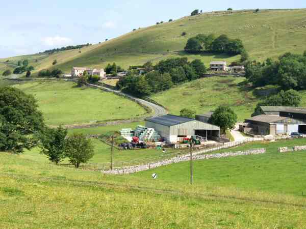
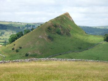
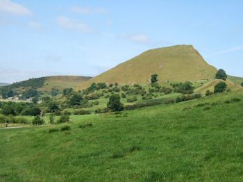
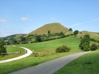
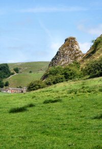
EARL STERNDALE WALK THE WALK Earl Sterndale, five miles south of Buxton, is ringed by beautiful hills such as Parkhouse, Chrome and High Wheeldon and superb walking country. Despite this it is a relatively unknown area, even for many of those who regularly walk in the Peak District. This short walk through stunningly beautiful countryside visits Dowel Dale looked down upon by Chrome Hill on the west side of the dale, and Parkhouse Hill on the east. Chrome is recorded as the highest Hill in the county and the urge to make a detour and climb it may prove irresistible on this walk. The view from the top on a clear day is magnificent. Important archaeological finds were made at Dowel Cave, which was used by the earliest known settlers in the White Peak. The cave dwellers lived by hunting, prey being plentiful in the area. During the earlier stages of the walk the route passes midway between Glutton and Glutton Grange, dated 1675. The cheese factory at Glutton, built in the 1870s, produced Wensleydale Cheese until the 1960s.
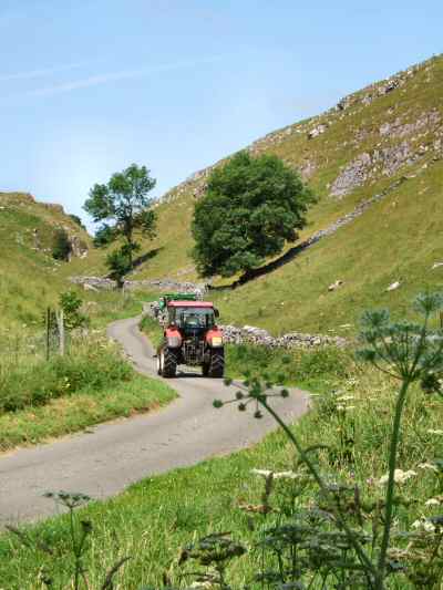
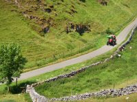
WALK DETAILS Length: 3 miles. An extra mile can be added by climbing Chrome Hill, see the footpath sign on the route to Dowall Hall. Start/Finish: Roadside car parking near the church. Location: From the North leave the A515 (2 miles South-East of Buxton) and follow the B5053 for two miles, before turning left signed for Earl Sterndale. From the South follow the B5053 to the village. Terrain: Through fields mainly used for sheep and cattle grazing and along quiet country lanes. There is one fairly easy descent near the start of the walk, as long as the correct path is followed. The climb out of Dowel Dale is quite steep, but short in length. The fairly steep climb up Chrome Hill (optional) is well rewarded by fine views.
THE ROUTE 1. Walk in front of the Quiet Woman Public House, going to the right, through a gap between the pub and an out-building. 2. Once through the gap, continue straight ahead at a sign post, taking the route for Hollinsclough. 3. Cross two further stiles and an access road, and continue straight on for a few yards to cross a stile into a field. 4. Angle to the left, passing close to the corner of another field, to reach the far left hand corner of the field. Go over a stile sited between a gate and a water trough. 5. Maintain the same direction across the next field and climb over a high wall stile. 6. Turn to the right and walk for a short distance through a boulder strewn area, before going to the left along a grass ridge. 7. Go right over a stile, by a yellow topped marker post and angle slightly to the left, to reach a stile at the bottom of the field. 8. Cross the road and the stile directly in front of you to enter a narrow field. Cross the field and go through a stile by a metal gate. 9. Angle to the left up a large field, aiming for the top corner of the hedge you can see in the distance. The field widens out slightly after reaching this point and you will see the stile a few yards in front of you. 10. Follow a discernable track across the next field as it very gradually goes to the left to join a quiet country road, near a finger post sign. 11. Ignore the foot path sign and follow the road round to the right to reach Dowall Hall (the road is unfenced, first on the right and then the left along this stretch). If you want to climb Chrome Hill, take the footpath sign on the left, before reaching Dowall Hall, and return to the same point after completing your climb. 12. Continue up Dowel Dale (note the difference in spelling), which is fenced on either side, until the road bends to the left, where you go over a stile on the right. 13. Aim a little to the right, up a short steep hillside, before crossing a stile into a field. 14. Head across the field aiming towards a marker post and Earl Sterndale that will soon come into view, to reach a stile by a metal gate. 15. Turn left and keeping close to the wall by the access track, walk down the field. About 30 yards after passing a metal gate, go over a stile, the access track and another stile into a field. 16. Cross the field at an angle of 45 degrees to the left, to reach a minor road by the way of a stile. 17. Turn right and continue along the road, crossing the B5053, to reach Earl Sterndale and the start of the walk.
Return to the Home Page Back to the top of the Page Return to the Contents Page www.derbyshire-peakdistrict.co.uk is an independent, not for profit website. No recommendation of any establishment is implied by inclusion on this website.
|
PLACES OF INTEREST IN THE LOCALITY
Manifold Valley Visitor Centre (Tel. 01298 84679) housed in the old Hulme End Station, where information displays outline the history of the railway, the industries and local community. Open most weekends and during school holidays. For further information, when the above number is not available, contact Leek Tourist Information Office (Tel. 01538 483741) who will be able to supply details.
Buxton Museum and Art Gallery (Tel. 01298 24658) award winning ‘Wonders of the Peak’ gallery. Programme of temporary exhibitions and displays. Well stocked shop. Open all year Tuesday to Saturday and Bank Holidays. On Sundays, the museum is open from Easter to the end of September.
Poole’s Cavern (Tel. 01298 26978) is located at Buxton, where guided tours are provided of the limestone cavern, famous for its stalactites and stalagmites. Ancient remains show the Romans worshipped here. There is a large car park, toilets, shop and drinks facilities available. Please telephone for opening details or visit website. In 2007, a new attraction - Go Ape - opened in Grin Low Woods situated at the other end of the cavern car park.
REFRESHMENTS
The Quiet Woman (Tel. 01298 83211) is an unpretentious pub, which attracts beer lovers from near and far who want to soak up its traditional atmosphere. The pub has won several awards and been mentioned every year but one since 1976, in the Good Beer Guide. Snacks are normally available at lunchtime and in the evening.
Longnor Craft Centre (Tel. 01298 83587) the home of Fox Country Furniture. Apart from furniture, exhibits of the work of local craftspeople and artists are also displayed. The café is open seven days a week from mid-February selling home baked produce. It is only open weekends from late December.
THE DISCOVER DERBYSHIRE AND THE PEAK DISTRICT GUIDE
Provides a wide range of features with heritage trails and detailed countryside walks, through some of the most scenically attractive countryside in the UK.
1. To return to the main site click the link below. 2. To return to the contents page of the main website click the link below.
DISCOVER DERBY A special new sub-section has been added to this website, based on the Discover Derby Supplement, published by the Derby Evening Telegraph during March 2005. The most recent additions are: Click below for details.
EARL STERNDALE FEATURE Earl Sterndale is a pleasant, unspoilt, working village, lying at 1,100 ft above sea level, surrounded by some of the most picturesque countryside in the Peak National Park. Unlike almost anywhere else in the park, apart from Thorpe Cloud, it has what many first time visitors to the area expect to find “peaks”. The Peak District took its name from the Pecsacetans, “the hill dwellers” who once lived in the area and not its mainly flat-topped hills, which tends to confuse the newcomer. The two dominant hills on the western side of the village, Parkhouse and Chrome, are conical in shape. High Wheeldon to the south east of Earl Sterndale is conical, but not so markedly so as the other two hills.
All details on this page were correct at the time of publication, but changes may be made without notification.
|