DISCOVER DERBYSHIRE
AND THE
PEAK DISTRICT
|
DISCOVER DERBYSHIRE AND THE PEAK DISTRICT |
|
ALSTONEFIELD WALK
THE WALK
A lovely walk down quiet Hall Dale, with superb views of the River Dove before crossing the river from Staffordshire into Derbyshire and walking along the dale to picturesque Milldale.
From Alstonefield the path drops steeply before climbing up to the tiny hamlet of Stanshope, little more than a cluster of farms and Stanshope Hall standing on a bend on the road to Ilam. The hall dates back to the 1500s but it has not always been as well kept as it is today. William Manley a money lender, with two mistresses who lived nearby, went bankrupt in 1799. Over the next 50 years, the house fell into disrepair before being rescued from dereliction in the 1850s.
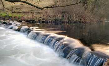
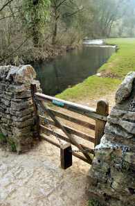
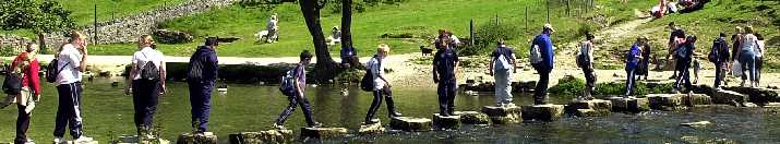
Hall Dale is a delightful dry dale leading down to Dovedale, which used to be covered with beds of snowdrops in the spring. Dovedale and the pretty hamlet of Milldale, swarming with visitors at weekends on a sunny, summer days’, are the highlights of the walk. Milldale is reached by crossing Viator’s Bridge, a packhorse bridge named after a character in the best selling book The Compleat Angler.
The walk is completed by a long steady climb up Millway Lane back to Alstonefield.
WALK DETAILS
Length: 4.5 miles.
Start/Finish: Car park in centre of village.
Location: Off the A515 Ashbourne to Buxton road.
Terrain: Hilly, the descent from Alstonefield is quite steep and can be muddy.
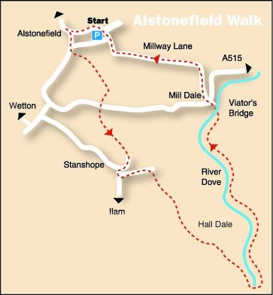
THE ROUTE
MESSAGE FROM STAFFORDSHIRE
HIGHWAYS: I
am contacting you in relation to a bridge deck replacement and disabled
access upgrade of Ilam Rock Footbridge in the Dovedale Valley, which
Staffordshire County Council is proposing to undertake starting 8th
September 2008 for a duration of 10 weeks.
Riverway Stafford ST16
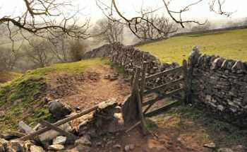
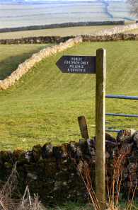
3TJ 1. From the car park, turn left to reach the road leading towards Hartington and then turn sharp left. Just past the next junction where the road starts to bend right, bear left between two houses and enter a grassy lane. 2. Where the lane curves sharp right you continue straight ahead, through a squeezer stile by a gate down the field with the wall on your right. 3. Bear right at the gap in the wall to locate a stile in the corner of the field. 4. Keeping close to the wall on the right carefully descend to a stile leading onto a minor road. Go over the road and walk up a grassy lane that climbs steadily up to Stanshope. 5. At the junction with the main road, adjacent to Stanshope Hall, turn left down the farm lane. Just before it starts to ascend turn right through a stile and walk to another stile a short way along the wall on your left. 6. The path leads across fields and stiles to the obvious gap in the hillside leading down Hall Dale, which you follow all the way down to the River Dove. 7. On reaching the river turn right to walk through woodland to the footbridge at Ilam Rock. 8. Go over the bridge and turn left to follow the path upstream to Milldale. 9. Cross Viator’s Bridge and walk in front of the toilet block over the road to enter a narrow lane leading upwards, in front of the cottage café. 10. The lane climbs up quite steeply back to Alstonefield.
Return to the Contents Page Back to the top of the Page Return to the Home Page
www.derbyshire-peakdistrict.co.uk is an independent, not for profit website.
No recommendation of any establishment is implied by inclusion on this website.
|
PLACES OF SPECIAL INTEREST IN THE LOCALITY Hartington, a picturesque village with a spacious market place, village green, delightful duck pond and limestone houses which sparkle in the bright sun-light, make it one of the major tourist centres in the Peak District. It is home to a cheese factory that produces a quarter of the world’s supply of Stilton Cheese. Visitors can buy the cheese at the factory shop. Thor’s Cave, rises 350 feet above the Manifold Valley, its 60-foot entrance is imposing but the cave inside is comparatively small. The railway track that once ran through the valley has been converted for the use of walkers and cyclists. The Manifold Valley Visitor Centre, at Hulme End (Tel 01298 84679) is housed in the old station, where information displays outline the history of the railway, the industries and local community. An extension is being added.Normally open at weekends and during school holidays. Leek Tourist Information Office (Tel. 01538 483741) will be able to supply further details. REFRESHMENTS The George (Tel 01335 310205) is a lovely country pub with a log fire in the bar and interesting pictures of events old and new in the area. Food is available lunchtimes and in the evenings every day. Beresford Tea Rooms (Tel. 01298 84418) Open seven days a week from Easter, this busy little café provides a good selection of light meals and teas. It also houses the village Post Office.
THE DISCOVER DERBYSHIRE AND THE PEAK DISTRICT GUIDE
Provides a wide range of features with heritage trails and detailed countryside walks, through some of the most scenically attractive countryside in the UK.
1. To return to the main site click the link below. 2. To return to the contents page of the main website click the link below.
DISCOVER DERBY A special new sub-section has been added to this website, based on the Discover Derby Supplement, published by the Derby Evening Telegraph during March 2005. The most recent additions are: Click below for details.
ALSTONEFIELD FEATURE
Alstonefield is an unspoilt upland village standing at an altitude of 900 feet, just over the Derbyshire border in Staffordshire. It was built on an ancient site where several trackways once crossed, later to become packhorse routes.
As packhorse trade declined and transportation by canal and then rail predominated, so Alstonefield’s location came to be more of a hindrance than an asset. For obvious geographical reasons, canal and railway engineers ignored the village, leaving it somewhat isolated.
Today, it is a village of attractive houses and gardens with plenty of open space, often covered with a triangle of grass rather than a square.
Read the feature, and discover the Heritage Trail by clicking the link at the foot of this page.
All details on this page were correct at the time of publication, but changes may be made without notification. |